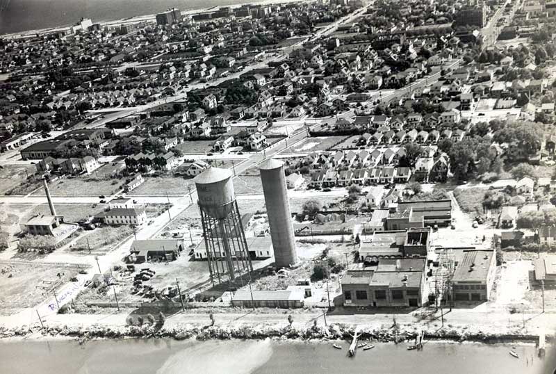
Aerial View looking south from around Riverside Blvd.
It just so happened that when I sent this photo to Sam Schwarzman it was the area in which he grew up. Sam provided this documentation of the photo, which was provided by the LB Historical Society.
There are 4 duplex houses visible over the top of the incinerator chimney, here is who lived in them when that shot was taken in the mid 50's. 1st house from the left, Grapski/Costagan, second, Holt/Gross, third Schwarzman (me)/Perez (Superintendent of Sanitation), Wallace/Larocco. If you look at Long Beach Road, you can see the city garage, across the street is Fleishaman's Lincoln Mercury. On the same side as Fleishman's is the custard stand "Custards Last Stand". The custard stand was owned by the Fleishman's and they tore it down build Fleishman's Ford on that property. There is so much more! What a great photo. If you look at the bay side shoreline, you will see the frame of a dock. My friends and I (Don Marcote and Larry Grapski) did build a dock on that frame. The new incinerator was built where you see the trucks parked, that was the city storage yard.
CLOSE THIS WINDOW TO RETURN TO THE PREVIOUS PAGE
Click here if you found this page from outside the main site and would like to go to the index page, otherwise, just close this window.